
River Restoration and Geomorphic Assessment Projects
|
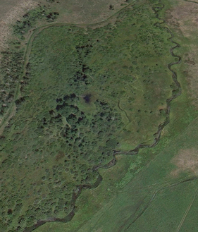
Big Wood Restoration - Bellevue Project Area, Idaho
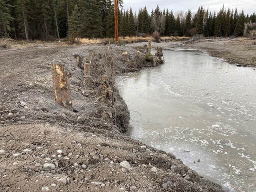
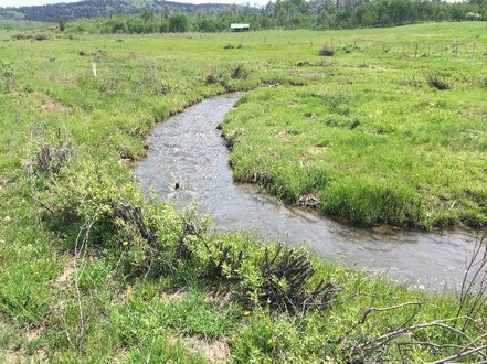
Biota was retained in 2019 by the Wood River Land Trust (WRLT) to complete a geomorphic assessment and conceptual design for the Big Wood River from the Broadford Road Bridge downstream to the southern extent of the Riverside Subdivision (Bellevue Reach). The approximately 1-mile reach geomorphic assessment and conceptual design was developed to maximize ecological benefits while protecting adjacent landowners from erosion and flooding potential. Since the reach-scale assessment was completed, Biota has been retained to complete and implement several site-specific restoration projects within the reach. Biota designed the District 45 Big Wood River Bank Stabilization Project in 2019 for the irrigation district to remove a relict retaining wall upstream of the headgate and replace it with a bioengineered bank stabilization design and headgate wingwall extension. The project was completed in 2020. Biota designed the Big Wood River Diversion Dam Remediation Project in 2020 and 2021 for the irrigation districts and TU. The project included burying the existing concrete diversion dam with a roughened rock ramp and low flow channel to provide fish passage over the vertical concrete dam and alleviate deterioration and scour downstream of the dam. The project proponents are currently pursuing funding for implementation. Biota designed the Lower Howard Preserve Project in 2020 and 2021 for the WRLT to open access to an existing high-flow side channel and improve floodplain inundation through a relict levee without increasing flood hazard to nearby properties. The project was implemented in early spring 2021 under Biota’s oversight. Finally, Biota designed the Bellevue Side Channels Project in 2021, and we are currently working with project area landowners to secure final permissions for project implementation. The project will restore hydrologic connectivity with two high-flow side channels to improve peak flow floodplain inundation, reduce energy and flooding potential to nearby homeowners and improve instream habitat conditions. The project was designed for the WRLT, and implementation is slated for 2022. |
|
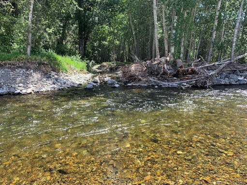
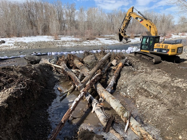
Big Wood River, Highway 75 Bridge Downstream Reach Project, Blaine County, Idaho
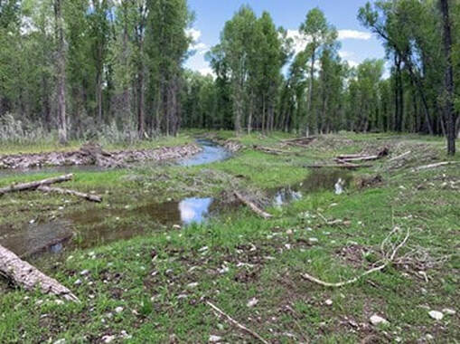
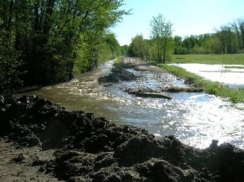
Biota Research and Consulting, Inc. was retained by a private client to complete a site assessment, restoration design, and permitting for the Big Wood River from the State Highway 75 Bridge near the hospital downstream to the Red Cliffs area. The project was completed to identify specific treatments to be implemented in order to protect proximate land uses and infrastructure while maximizing the fluvial and ecological values of the river system. The primary strategy to meet project objectives was to restore function through application of in-channel treatments that enable the river to convey hydrologic and sediment inputs without severe erosion or deposition. Final project included design and implementation on 1500 feet of channel, bank and floodplain restoration on a private property severely eroded during the 2017 and 2018 peak runoff events. Project included topographic survey, no-rise hydraulic modeling, and restoration design for the reach of the Big Wood River, including full bank stabilization design
The project has functioned as designed since the project was implemented in the winter 2020. Project activities established self-sustaining and stable functional channel with a well-connected floodplain. The two high-flow side channels (Side Channels A and B) did not receive flow during runoff due to the relatively low magnitude peak flow. Side Channel C did receive and convey flows during periods of elevated runoff levels during 2021.
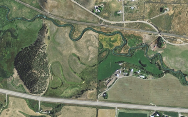
Teton River Restoration, Bates Project, Teton County, Idaho
Biota was retained by Friends of the Teton River and the Teton County Idaho Public Works Department to complete geomorphic assessment, river restoration design, floodplain mapping and permitting, and construction oversight on this local high-profile project on the Teton River. The project area is located immediately downstream from a high use boating access ramp at the Bates Road Bridge. Biota conducted a bathymetric survey that covered over 7,000 ft (river length) and integrated the bathymetric data into available LiDAR data to develop a 2-Dimensional hydraulic model for design purposes, mapping of the base flood conditions, and permitting through the local Teton County Floodplain Regulations. Project treatments included bioengineering bank stabilization treatments with willow fascines, willow clump transplants, wetland creation, channel narrowing floodplain bench treatments, and toe wood.
Biota completed construction staking and construction oversight in the fall of 2020.
Middle Fork Popo Agie River Project, Fremont County, Wyoming - Popo Agie Conservation District
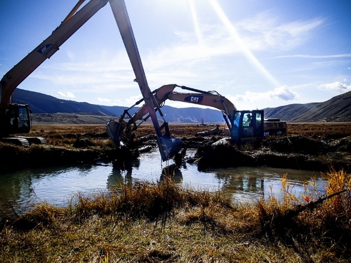
Biota was retained by the Popo Agie Conservation District to develop a stabilization and flood mitigation project for the Popo Agie Estates Subdivision Homeowners Association (HOA) on the Middle Fork Popo River near Lander, WY. The intent of project was to identify designs that both address the threat of flooding and maintenance issues currently faced by the Popo Agie Estates HOA and Fremont County while improving river function, floodplain conditions, aquatic and riparian habitats, and riparian conditions. The project included an alternatives analysis for a design plan to replace existing pushup berm and sand bags with an improved flood control structure, increase side channel connectivity, replace damaged irrigation infrastructure, bioengineered bank stabilization treatments, and remove channel profile discontinuities. Biota was responsible for surveys, data analysis, design development, reporting, permitting, construction bidding, construction oversight, and a post-construction review. Construction was completed in the fall of 2021.
Biota was retained by the Popo Agie Conservation District to develop a stabilization and flood mitigation project for the Popo Agie Estates Subdivision Homeowners Association (HOA) on the Middle Fork Popo River near Lander, WY. The intent of project was to identify designs that both address the threat of flooding and maintenance issues currently faced by the Popo Agie Estates HOA and Fremont County while improving river function, floodplain conditions, aquatic and riparian habitats, and riparian conditions. The project included an alternatives analysis for a design plan to replace existing pushup berm and sand bags with an improved flood control structure, increase side channel connectivity, replace damaged irrigation infrastructure, bioengineered bank stabilization treatments, and remove channel profile discontinuities. Biota was responsible for surveys, data analysis, design development, reporting, permitting, construction bidding, construction oversight, and a post-construction review. Construction was completed in the fall of 2021.

Snake River Restoration Project, Teton County, Wyoming
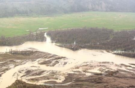
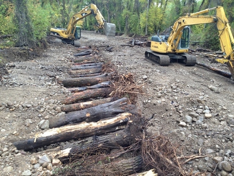
Biota was retained to complete a large-scale river bank restoration project on the mainstem Snake River in Teton County, Wyoming. The project reach is a Wild and Scenic Rivers Act (WSRA) designated river. Field surveyed bathymetric data was integrated into the available LiDAR to generate a surface of the project reach. That surface was used to develop a 2-Dimensional hydraulic model that was used to develop a bioengineered river bank stabilization project, to assess existing and proposed 100-year flood conditions, to demarcate the base flood inundation area and flood depths, and to ensure compliance with the local floodplain development regulations.
Biota was responsible for site assessments, data analysis, modeling, design development, permitting, and construction oversight. Project designs included log jam deflector structures, reinforced toe wood, and willow pole bundles along the channel banks along about 960 linear feet of Snake River bank. The project designs utilized vertical piles for scour protection eliminating the need to use rip rap. The specific configuration of the bioengineered bank stabilization treatments was developed through an iterative hydraulic modelling process. The project was constructed in the spring of 2021.
Buffalo Fork Utilities Protection Project, Teton County, Wyoming
Biota was retained in 2021 by Lower Valley Energy for design and permitting services for a project to protect a utility power pole that was in jeopardy from localized severe bank erosion on the Buffalo Fork of the Snake River. The project reach of the Buffalo Fork is a Wild and Scenic Rivers Act (WSRA) designated river in Grand Teton National Park. This project was viewed as an emergency effort by Lower Valley Energy in order to avoid a potential power outage and dangerous repair work during river flooding. Project designs included two log jam deflector structures and reinforced toe wood along the channel banks. The project designs utilized vertical piles for scour protection eliminating the need to use rip rap.
Biota was responsible for project design, construction oversight, and permitting--which included a WSRA Section 7 analysis, a Grand Teton Nation Park Special Use Permit, a U.S. Army Corps of Engineers Nationwide Permit, and a Wyoming Department of Environmental Quality Clean Water Act 401 Certification
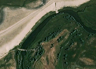
Morel Creek Fish Habitat Enhancement Project, Teton County, Wyoming
Biota was retained by a private landowner to develop a restoration design plan for Morel Creek, which is a relict flood channel of the Snake River located adjacent to Fall Creek Road south of Wilson, Wyoming. Prior to the construction of the Snake River flood protection levee, seasonal spring peak flows in the Snake River inundated riparian lands adjacent to the river channel. Uncontrolled spring runoff established and maintained flood channels throughout the riparian area under dynamic fluvial conditions. The Morel Creek project enable surface water to access riparian zones and relict flood channels on the landward side of the Snake River levees to restore fluvial processes previously precluded by the Snake River levee system. The project included excavation and enhancement of an approximately 8,000-ft reach of Morel Creek. Project treatments included excavation of the Morel Creek channel to improve groundwater hydrologic connectivity and the additions of aquatic habitat features. A wetland delineation was performed within the Morel Creek project area to identify areas for nearly 2 acres of wetland creation.
The project was constructed in late fall of 2019 and resulted in the establishment of a 1.5-mile long spring creek that provides spawning and refuge habitat for native Snake River fine-spotted cutthroat trout. The project also increased the quality of the Snake River riparian corridor by constructing benches for natural cottonwood regeneration, increased wetland habitat, and improved hydrologic conditions for riparian vegetation success throughout the reach.
Spring Creek and Cody Creek Restoration Project, Indian Springs Ranch, Teton County, Wyoming
Biota was hired as prime contractor to complete geomorphic assessment, design, permitting, construction implementation, and post-project monitoring during this multidisciplinary project that improved fisheries and ecological values on an active agricultural property. Biota worked closely with the Teton Science Schools (landowner) and the Indian Springs Ranch home owner association to develop and implement a project that achieved multidisciplinary benefit.
A total of 1.2 miles of Spring Creek and 1.4 miles of Cody Creek were restored through construction of a stable channel form designed using a Natural Channel Design approach. In addition, 4 existing diversions were rebuilt to improve irrigation operations and benefit fisheries components, off-channel livestock water facilities with solar pump sources were installed, fish screen were installed on existing diversions, and 1,000 dormant woody (willow and cottonwood) plantings were installed to improve riparian conditions. Post-project monitoring during the first year documented 61 pair of Snake River fine-spotted cutthroat trout spawning within the project area.
Gros Ventre River Tributary Restoration Project - Teton County, Wyoming
Biota was hired by Trout Unlimited (the Snake River Headwaters Project Manager and the Jackson Hole Chapter) and the Trust For Public Lands to conduct this ongoing watershed restoration project. The project objectives are to restore system impairment in four tributaries to the Upper Gros Ventre River that were historically impacted more than 110 years ago during homesteading of the area. Remnant stream impacts include obliteration of historic channels, disconnection between tributaries and the Gros Ventre River mainstem, persistence of irrigation ditches that capture stream and spring flows, and morphologic and structural barriers to fish passage. Biota's ongoing work on this project includes site assessment, geomorphic and topographic survey, hydrologic and hydraulic analyses, and development of system restoration alternatives to maximize fisheries and fluvial conditions in this remote ecosystem.
Biota was hired by Trout Unlimited (the Snake River Headwaters Project Manager and the Jackson Hole Chapter) and the Trust For Public Lands to conduct this ongoing watershed restoration project. The project objectives are to restore system impairment in four tributaries to the Upper Gros Ventre River that were historically impacted more than 110 years ago during homesteading of the area. Remnant stream impacts include obliteration of historic channels, disconnection between tributaries and the Gros Ventre River mainstem, persistence of irrigation ditches that capture stream and spring flows, and morphologic and structural barriers to fish passage. Biota's ongoing work on this project includes site assessment, geomorphic and topographic survey, hydrologic and hydraulic analyses, and development of system restoration alternatives to maximize fisheries and fluvial conditions in this remote ecosystem.
Lanes Creek Restoration Project - Caribou County, Idaho
Biota was hired as project lead to complete channel assessment, design, permitting, construction supervision, and post-project monitoring during this large scale restoration project in eastern Idaho. Project activities include restoration of a 3-mile reach of entrenched and degraded stream in the headwaters of the Blackfoot River basin. Project objectives include habitat enhancement for all age-classes of native Yellowstone cutthroat trout.
Biota staff applied an Natural Channel Design approach to complete hydrologic and geomorphic assessment of the entire project reach, and analysis results were utilized to develop a comprehensive fluvial restoration plan in 2013. Phase 1 of construction was completed in the fall of 2013, and the remainder of the project was constructed under Biota’s supervision in the fall of 2014.
Stable channel morphology and aquatic habitat improvements were designed based on hydrologic regime, geomorphic condition, sediment conditions, and site attributes. Project treatments include reconstruction of stable channel morphology; restoration of floodplain connectivity; bank stabilization; channel elevation and grade control structures; restoration of pool-riffle sequences; revegetation and re-establishment of woody vegetation; improvement of fish passage through culvert modification; riparian exclosure fencing (to exclude approximately 20 acres); and construction of 6 off-channel livestock water facilities. This regional demonstration project was funded by a diverse partnership of state, private, non-profit, and private sector stakeholders.
BEFORE
|
AFTER
|
Flat Creek Restoration Project - National Elk Refuge, Jackson, Wyoming
Biota was hired by the local chapter of Trout Unlimited and the Wyoming Game and Fish Department to restore stable channel morphology to improve habitat for native Snake River fine-spotted cutthroat trout in Flat Creek on the USFWS National Elk Refuge. Hydrologic investigations and geomorphic assessment were completed to investigate current fluvial conditions and system impairments. A channel restoration and fish habitat enhancement design was specified to achieve appropriate channel morphology based on local hydrologic regime and sediment inputs. Previously installed treatments were removed and stable channel morphology was constructed in order to achieve aquatic habitat enhancement objectives.
The design included some instream structures, but emphasis was placed on reconstructing channel dimensions using vegetative treatments (sod mat layering, gravel placement, woody member installation) and establishing design profile and bed features through placement of appropriately sized substrate. Phase 1 of the project was implemented in 2013 and post-project monitoring conducted by the Wyoming Game and Fish Department documented increased fish utilization and spawning activities of wild Snake River cutthroat trout. Phase 2 of the project was implemented in the fall of 2015, and the final phase (3) of the project is scheduled for implementation in 2016.
This high profile project was funded by a collaborative group the included Trout Unlimited, Wyoming Game and Fish Department, Snake River Fund, National Fish and Wildlife Foundation, Teton Conservation District, Rocky Mountain Elk Foundation, Wyoming Wildlife and Natural Resource Trust, and private donors.
View a short Wyoming Game and Fish Department video that highlights the Flat Creek Restoration Project:
Snake River Geomorphic Assessment and Stabilization Project, Teton County, Wyoming
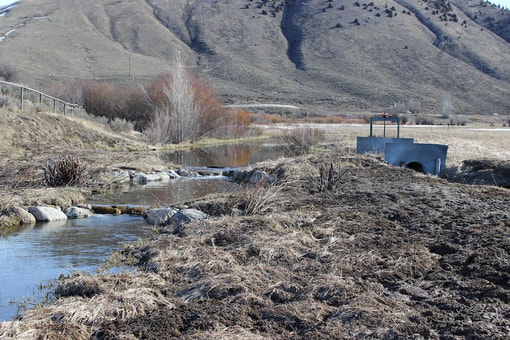
Biota was hired by the Teton County Road and Levee Department and the Teton County Engineering Department to design, permit, and implement solutions to severe lateral channel migration, bank erosion, and flooding along the Snake River south of Jackson, Wyoming. Geomorphic assessment and related analyses were used to develop a design that incorporated various instream structures to stabilize stream banks and protect private lands while addressing concerns of localized flooding and threats to public health, safety, welfare, and county road infrastructure. The effort achieved project objectives of bank stabilization and flood control along a reach of the flashy Snake River where peak flows have reached 30,000 cubic feet per second (cfs).
Teton Creek Restoration Project - Driggs, Idaho
Biota was initially hired to conduct a geomorphic assessment of an anthropogenically altered 2-mile reach of Teton Creek, and to assess the validity and appropriateness of an existing restoration plan. Biota completed a comprehensive geomorphic analysis of existing and proposed channel conditions, which revealed inadequacies in the existing design associated with sediment transport and fluvial function. Based upon our findings, Biota was hired to compile an appropriate final project design that was implemented during a $2.6 million restoration effort of more than 1 mile of the creek located in Driggs, Idaho.
The project involved reconstruction of stable channel morphology; achievement of sediment transport discontinuity; riffle-pool sequence construction; restoration of channel planform and profile; construction of specific channel geometry based upon sub-reach slope; reconstruction of inset floodplain; and revegetation/woody vegetation establishment measures. Biota developed the final restoration design in 2013 and the project was constructed in the fall/early winter of 2013.
The project received support and funding from diverse and collaborative interests including Western Native Trout Initiative, Idaho Department of Environmental Quality, Idaho Department of Water Resources, National Fish and Wildlife Foundation, Jackson Hole One Fly Foundation, Idaho Department of Fish and Game, Natural Resources Conservation Services, Teton County, City of Driggs, and FEMA.
View a short video broadcast by local Idaho News Channel 8 that highlights the Teton Creek Restoration Project:
Fish Creek Restoration Project, Snake River Ranch, Teton County, Wyoming
Biota was hired to complete site assessment, restoration design, permitting, and construction supervision of this stream restoration project in upper Fish Creek. The project design was completed using Natural Channel Design methods in order to identify functional channel dimension, pattern, and profile. The project accounted for anthropogenic alteration of local hydrologic regime, sediment inputs, and land use constraints on an active agricultural property. Project completion resulted in maximized fisheries and ecological values while complimenting on-site ranching and farming activities.
Badger Creek Project, Teton County, Idaho
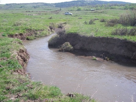
Biota worked for the Teton County Idaho Engineering Department to design stabilization activities within and adjacent to Badger Creek to control flood waters, halt severe erosion, prevent loss of public infrastructure and private lands, and comply with regulatory requirements. Based upon hydrologic analysis, geomorphic assessment, and sediment transport modeling and hydraulic condition assessment, a stable channel morphology was designed and constructed through channel grading and incorporation of various hard and soft treatments. The project was implemented in 2012, and has functioned well to demonstrate that county infrastructure can benefit from appropriate fluvial system improvement efforts. The effort restored proper fluvial process, protected public infrastructure and safety, and rectified flood conditions that have destroyed Teton County roadways numerous times in the recent past.
Biota worked for the Teton County Idaho Engineering Department to design stabilization activities within and adjacent to Badger Creek to control flood waters, halt severe erosion, prevent loss of public infrastructure and private lands, and comply with regulatory requirements. Based upon hydrologic analysis, geomorphic assessment, and sediment transport modeling and hydraulic condition assessment, a stable channel morphology was designed and constructed through channel grading and incorporation of various hard and soft treatments. The project was implemented in 2012, and has functioned well to demonstrate that county infrastructure can benefit from appropriate fluvial system improvement efforts. The effort restored proper fluvial process, protected public infrastructure and safety, and rectified flood conditions that have destroyed Teton County roadways numerous times in the recent past.
Portneuf River Geomorphic Assessment - Southeastern Idaho
Biota completed geomorphic assessment and compiled a comprehensive restoration design for a 7-mile reach of the Portneuf River located just downstream of Lava in southeastern Idaho. The project was completed for Trout Unlimited and the Portneuf River Partners, a collaborative group comprised of agency personnel, conservation groups, landowners, and interest groups. Biota applied a quantitative approach to riverine assessment that included hydrologic modeling; geomorphic assessment; channel surveys; substrate sampling; hydraulic analysis; sediment transport modeling; and development of conceptual restoration design treatments for the entire project reach in order to restore and enhance the anthropogenically altered watercourse.
Biota completed geomorphic assessment and compiled a comprehensive restoration design for a 7-mile reach of the Portneuf River located just downstream of Lava in southeastern Idaho. The project was completed for Trout Unlimited and the Portneuf River Partners, a collaborative group comprised of agency personnel, conservation groups, landowners, and interest groups. Biota applied a quantitative approach to riverine assessment that included hydrologic modeling; geomorphic assessment; channel surveys; substrate sampling; hydraulic analysis; sediment transport modeling; and development of conceptual restoration design treatments for the entire project reach in order to restore and enhance the anthropogenically altered watercourse.
New Fork River Restoration Project - Sublette County, Wyoming
Biota completed site assessment, design, permitting, and implementation of this project. The project focus was to restore fish passage, improve the ecological values of the area, and sustain ongoing agricultural operations. The persistence of an established earthen dam across the river channel maintained a barrier to fish passage, resulted in severe local sedimentation, seasonal increases in water temperature, and severe fluctuations in dissolved oxygen levels. Biota designed and implemented a system solution that included dam removal, construction of a quarter mile of stable functional river channel, and relocation of the two diversions to an upstream reach in order to increase hydraulic head at the ditch inlets and accommodate agricultural operation requirements.
The project resulted in restored fishery access to a nearly 3-mile reach of river habitat, while accommodating the needs of the local agricultural operation.
 BEFORE BEFORE
|

AFTER
|